~~~~~~~~~~~~~~~~~~~~~~~~~~~~~~~~~~~~~~~~~~~~~~~~~~~~~~~~~~~~~~~~~~~~~~~
POLITICS
The capital of Pennsylvania is Harrisburg, which is where the state legislature meets and where the governor works. The current governor is Tom Wolf (D). Previously, it was Tom Corbett (R) and before that, it was Ed Rendell (D). The state legislature is officially known as the General Assembly, which is bicameral. The Senate contains fifty members and there are 203 in the House of Representatives, which is very large compared to other state legislatures. Currently, both chambers have large Republican majorities. Specifically, there are 30 Republican state senators to 20 Democrats. In the House, there are 119 Republican representatives to 84 Democrats. In terms of federal representation, Pennsylvania sends one Democratic and Republican senator each to the Capitol. Of its 18 representatives, five are Democrats and the other 13 are Republican.
The most recent election that voted Republican Governor Tom Corbett out of office in favour of Democrat Tom Wolf was rather unremarkable, with relatively large margins between the two candidates. Tom Corbett was seen as a weak governor with low approval throughout his term and was widely viewed as vulnerable to losing the gubernatorial election of 2014.

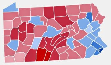
The trends seen in this map of which counties voted for which governor (red is Republican and blue is Democratic) are reliable in that they can be extended to similar ones regarding presidential elections. Generally, urban areas tend to vote Democratic and rural ones vote Republican. In the far northwest is Erie county with its seat of Erie, the fourth largest city in the state. The Democratic counties in the southwest surround Pittsburgh of Allegheny County, the second largest city in the state. In the middle, you see Centre County voting Democratic probably because of State College which has the university of Penn State. Dauphin County, which contains the state capital of Harrisburg, voted Democratic. Finally, most of Eastern Pennsylvania voted Democratic because it is the most urbanised area of the state. In the southeast, you see Philadelphia, the largest city of the state, extending its influence into surrounding Delaware Valley counties. Further up north in the east, it remains Democratic because of the Lehigh and Wyoming Valleys which contain the cities of Allentown and Scranton, respectively.
Previously, Pennsylvania consistently had the second most electoral votes so it was very important in presidential elections. Recently, its importance has somewhat diminished but still has 20 electoral votes, so it is a considerably important state, especially because it is a swing state. Despite voting Democratic in several of the most recent presidential elections, the margins are not very wide.
This picture shows the results by county of Pennsylvania, with red having voted for Mitt Romney and blue for Barack Obama in 2012. Like in the picture above, the same trends continue, though with stronger Republican support this time. Erie is in the far northwest, Pittsburgh is in the west, State College is in the centre, Harrisburg is a centre-east, Scranton/Wilkes-Barre in the northeast, Allentown in the east, and Philadelphia & company (suburbs) in the southeast.


These pictures show results from other presidential elections. The first picture shows the election of 2008 between Obama and John McCain, with similar results. Next is 2004 with George W. Bush and John Kerry. Third is 2000 with Bush and Al Gore. Last is 1996 with Bill Clinton and Bob Dole (third party candidate Ross Perot carried no counties but a significant share of the popular vote, at about 10%).
~~~~~~~~~~~~~~~~~~~~~~~~~~~~~~~~~~~~~~~~~~~~~~~~~~~~~~~~~~~~~~~~~~~~~~~
CLIMATE


In general, most of Pennsylvania has a humid continental climate with warm and humid summers, but cold winters. However, one exception is in the southeastern part of the state around Philadelphia in the Delaware Valley. This part of the state has humid subtropical climates with hot and humid summers, but cool winters. One thing in common is that Pennsylvania is relatively wet statewide, averaging 41 inches of rain a year. Floods are most common in the spring because of more rain, but mostly the snowmelt. The state is rarely affected by tropical storms and hurricanes, but does get them every few years.
Pennsylvania's climate has a general trend as you move from east to west. This includes decrease in temperature, more variable temperatures, and more cloudiness. Increased variability can be explained with the geography, because as you move west, you move further inland, away from the temperature moderating effects of the ocean and gulf stream. In addition, the decrease in temperature can be explained because the Appalachian Mountains run right through the state, so west of it is colder.
Snowfall varies widely across the state, with relatively little in the southeast but a lot more as you go north and west to places like Scranton, Pittsburgh and especially far northwestern Erie, which can receive over 100 inches annually because of lake effect snow. I say relatively because places like Philadelphia do see snow but it's much less compared to the north and west. The north and west are also more stable in the snowfall amounts, but the southeast sees greater variability. For example, some winters Philadelphia receives little to no snow. However, in other winters, the city can easily see several snowstorms which brings its total closer to that of the north and west.
No comments:
Post a Comment