Saturday, 21 March 2015

3.5 - Physical Geography

Before you read this section, I would like to point out that I have omitted the "Elevations" part of this section, mainly because when I was compiling this information, most of the information I would have included in that section became parts of the other Region and River parts.  It will no longer be on the final atlas, either.  In all, thirteen regions and eight rivers of Pennsylvania are addressed in this section, which is primarily text.


~~~~~~~~~~~~~~~~~~~~~~~~~~~~~~~~~~~~~~~~~~~~~~~~~~~~~~~~~~~~~~~~~~~~~~~

REGIONS


As with any Physical geographic map, borders aren't as applicable because they are an artificial invention.  The "borders" you see are actually more like blurry lines.  In reality, there are several way of arranging Pennsylvania into regions, with the simplest just using the cardinal directions.  This specific arrangement of regions uses slightly modified borders of several real regions of Pennsylvania, making it an original arrangement that accurately captures much of what this state has to offer physically.  You might notice some of the borders are a bit jagged, which is because these regions are made up of counties.  Knowing which counties belong to which region is irrelevant and that is saved for the political geography section of the atlas.

Northwest - This region has its centre on the city of Erie.  Away from the city, it eventually transitions to forest as population density decreases.

Forest - Contains large oil and gas deposits, but especially noted for its several varieties of hardwood trees.  Most of this region of Pennsylvania is protected.

North - This heavily rural and sparsely populated region is also called the Northern Tier. Unfortunately, it is one of the poorest regions of Pennsylvania with relatively few fossil fuel formations compared to other regions.

Mountains - Part of the Appalachian mountains, this region is somewhat of a misnomer because it is more plateau rather than mountain.  Glaciers from the last ice age have left several marks on this area.

Wyoming Valley - This region is a heavily populated metropolitan area also known as Scranton/Wilkes-Barre, cities that experienced a boom both in terms of their population and economy during the industrial era of Pennsylvania.

Poconos - Still part of the Allegheny Plateau, this region is also popular as a tourist and vacation area for local residents.

Greater Pittsburgh - Includes most of Southeastern Pennsylvania.  Unlike Philadelphia, Pittsburgh doesn't receive its own county.  This region consists of several counties that border or are close to Allegheny County, which houses Pittsburgh.

Intersection - The only novel region that was created specifically for this atlas, which means what it says:  This region is a crossroads between all the regions it borders.  Many region maps of this state would have several regions intersect in the middle of this region.

Ridge & Valley - Occupies most of Central Pennsylvania.  The Appalachian mountains are much smaller than the Rocky Mountains in the Western USA, but are much older.  Running from the southern USA to New England, the Applachians are said to be the most prominent in Pennsylvania. This region is named because the Appalachian mountains are not one single mountain chain, but rather consists of several smaller units.  Here, there are several near parallel ridges that alternate with valleys between them, almost giving this region of Pennsylvania a striped appearance.  It also explains why some of the counties in this region are oddly shaped.

Coal - Obviously, this is a historically important coal-mining area.  This is why the Wyoming Valley has grown into a large metropolitan area.  Scranton/Wilkes-Barre is actually a part of this region, but is split from this region mainly because it is more urban than the part of Coal region shown here, which is more rural and dedicated to coal-mining.

Piedmont - The Piedmont is, like Ridge and Valley, another part of the Appalachian mountains.  East of the Appalachians, it is a large hilly plateau that allows the Appalachians to risk to their peaks a bit west.  This word is French for "foothill".

Lehigh Valley - Named for the Lehigh River which runs through it, this region is the third largest metropolitan area behind Philadelphia and Pittsburgh because it houses the third largest city in the state, Allentown. The population of this region of the state is growing very rapidly and other towns aside from Allentown such as Bethlehem (remember the steel?), Easton, and Phillipsburg.

Delaware Valley - This is the most populated and lowest lying region of the state because of Philadelphia.  Obviously it is the river valley of the great Delaware river which forms the eastern border of the entire state of Pennsylvania.  This region is heavily urbanised and several suburbs of Philadelphia are rather large.  However, there is also much agricultural activity because the land is also rather flat unlike the rest of the state.

~~~~~~~~~~~~~~~~~~~~~~~~~~~~~~~~~~~~~~~~~~~~~~~~~~~~~~~~~~~~~~~~~~~~~~~

RIVERS

In the picture below, rivers are not labelled with names but listed as numbers.  The numbers given show in what order it appears in the text explanations of each river below.  For example, the river marked as "1" on the map corresponds with the Delaware River because that appears FIRST in the explanations.

Each number is listed twice to show the beginning and end of each river in the state.


Delaware - At 301 miles, this empties into the Atlantic through the Delaware Bay.  The origin of the Delaware is found in New York's Catskill Mountains, part of the Allegheny Plateau.  It is actually more accurate to pluralise the word "origin", because this river has two origins, the east and west branch Delaware.  The course of the Delaware defines the eastern border of the state of Pennsylvania and feeds several cities including Easton, PA and the capital of New Jersey, Trenton.

Schuylkill - At 135 miles, this is a branch of the Delaware that flows through Philadelphia.  It originates in Schuylkill County near the county seat of Pottsville.  The Schuylkill river has several tributaries including, but not limited to, the Wissahickon and Perkiomen Creeks.  This river flows through Berks county and its county seat of Reading.  It also marks the border between Montgomery and Chester counties, flowing through Pottstown, Montgomery County as well as its county seat of Norristown.

Lehigh - At 109 miles, this is a branch of the Delaware and forms the densely populated Lehigh valley.  It originates in the Poconos as a very fast flowing river, making it popular for whitewater rafting.  It feeds the county seat of Carbon County (Jim Thorpe) as well as another city in the county, Lehighton.  It also flows through the seat of Lehigh County, Allentown, as well as the city of Bethlehem in both Lehigh and Northampton Counties and the seat of Northampton County, Easton.

Susquehanna - At 464 miles, this is the longest river of the USA's East Coast that empties into the Atlantic through the Chesapeake Bay at Havre de Grace, Maryland.  It originates in New York and flows through Wilkes-Barre, seat of Luzerne County and marks the border of several other counties in Pennsylvania.  The Susquehanna also flows through the state capital of Harrisburg (also seat of Dauphin County).

West Branch - At 243 miles, this is the longest branch of the Susquehanna.  Originating in Cambria County, it flows through the seat of Lycoming County, Williamsport.

Ohio - At 981 miles, most of which are not in Pennsylvania, this is formed by the Monongahela and Allegheny at Pittsburgh.  Only the very beginning of the Ohio River is in Pennsylvania, more specifically the far west.  The rest of the Ohio forms the border between several states including West Virginia, Ohio, Kentucky, Indiana, and Illinois before joining with the Mississippi which flows south and empties into the Gulf of Mexico in Louisiana.

Monongahela - At 130 miles, this meets with the Allegheny at Pittsburgh to form the Ohio River. Originating in West Virginia, it flows north into Pennsylvania.

Allegheny - At 325 miles, this meets with the Monongahela at Pittsburgh to form the Ohio River.  It originates in Potter County and makes several bends so part of it is even in New York, before generally flowing south and joining the Ohio.

Thursday, 12 March 2015

3 - Vee Logarithm

Commented on the blogs of: Jason Shu, Eric Lang, and Simon Schiller

Friday, 6 March 2015

2.75: Overview - History and Demographics

Each part of this section will probably take up more than one page.  If this trend continues, then this atlas is going to be very long.  Not just in terms of pages, but also in terms of time taken to make it.  I spent about four hours working on this section of the atlas, as well as another four hours yesterday with "Where in the world?"  Well, then again, they say it takes 10,000 hours to achieve mastery - and I've just put in eight (this, of course, does not count all the other time I've put into research).  Anyway, I may have to revise my approach to dealing with the counties if I want to keep my sanity...

~~~~~~~~~~~~~~~~~~~~~~~~~~~~~~~~~~~~~~~~~~~~~~~~~~~~~~~~~~~~~~~~~~~~~~~

HISTORY OF PENNSYLVANIA

- Pre-Columbian Period

Prior to European contact, several Native American tribes lived in the state we know today as Pennsylvania, many of which were related (especially through language) to the powerful Iroquois to the north.  Europeans arrived first as explorers, then as traders, and finally as settlers and colonists during the 16th and early 17th centuries.


- Colonial Period

In 1638, Peter Minuit established the colony of New Sweden along the southern Delaware River and built the first log cabins of Pennsylvania.  However, in 1655, the Dutch captured New Sweden.  The Dutch and English fought over this territory in the Second and Third Anglo-Dutch Wars before the English consolidated their rule over the land in 1674.  Meanwhile, the French had settled Western Pennsylvania as part of their larger colony of New France.

The official history of Pennsylvania begins in 1681 when English King Charles II grants the Province of Pennsylvania (Penn's Woods) to William Penn, who used Pennsylvania as a place of religious freedom for the Quakers.  A year later, he landed in Pennsylvania and founded the capital of Philadelphia.  Several other religious and ethnic minorities settled in Pennsylvania and quickly diversified the population of the state.  Pennsylvania also held joint rule with the state of Delaware over its three counties.  William Penn was also very fair in his dealings with the Native Americans such as the Lenape, but relations deteriorated after his death in 1718 when his descendants weren't as friendly with the Native Americans.  The British gained Western Pennsylvania from the French in the French and Indian War of 1754 to 1763. 

- Revolutionary Period

The British, having incurred heavy debts from the war, began to tax the colonists more and more.  The colonists were outraged with these taxes and contributed to tensions that led to the first and second Continental Congresses in Philadelphia which brought together delegates from the 13 British colonies.  The Declaration of Independence was written in Philadelphia's Independence Hall and ratified on 4 July, 1776.  It is here when Benjamin Franklin rose to prominence as one of the founding fathers of the nation, as he fought tirelessly for revolution.  Pennsylvania was the site of several important events in the Revolutionary War, such as Washington's crossing of the Delaware River as well as Washington's gruelling winter stay in Valley Forge in 1777-1778. 

Pennsylvania had begun to abolish slavery in 1780.  In 1781, the Articles of Confederation was written in Philadelphia, which was now the new USA's capital.  By the end of the decade, the Constitutional Convention was held in Philadelphia to rewrite the Articles of Confederation which ultimately led to today's Constitution.  Pennsylvania was the second state to ratify this document at the end of 1787 and therefore was second to join the union after Delaware.  The first President George Washington stayed in Philadelphia which was the USA's first capital. 

Expansion of Pennsylvania.  Much of the time these were at the expense of the Native Americans. 


- American Period

In the early years as a state, Pennsylvania had gradually marked its borders and expanded west.  Pennsylvania remained one of the largest states of the USA until recently and held the second most electoral votes until 1960.  Similarly, Philadelphia was one of the largest cities of the USA and for most of the 19th century, the second largest behind New York City.  Pennsylvania was one of the key Union states during the Civil War, as the Battle of Gettysburg (in southern Pennsylvania) was the largest battle by casualty in the Civil War.  Union forces defended against the incoming Confederates and eventually claimed victory.  The battle is widely considered as the, or one of, the turning points of the Civil War.

After the war, Pennsylvania generally voted Republican (Lincoln's party) until the Great Depression.  Pennsylvania underwent a large scale of industial expansion after the Civil War and was a mecca of steel with the Carnegie and Bethlehem Steel Companies.  Oil and coal were also discovered and drilled/mined in large quantities.  As part of this industrialisation, the city of Pittsburgh rose to prominence in Western Pennsylvania.

After the Great Depression and WWII, post-industrialisation hit Pennsylvania hard, especially with the collapse of the steel industry, which put thousands out of work.  The urban centres of Philadelphia and especially Pittsburgh recorded large population losses.  Fortunately, both cities have managed to rebound with new focuses on science, technology, medicine, and education. 

~~~~~~~~~~~~~~~~~~~~~~~~~~~~~~~~~~~~~~~~~~~~~~~~~~~~~~~~~~~~~~~~~~~~~~~

DEMOGRAPHICS OF PENNSYLVANIA

- Population Density

This population density map of Pennsylvania is from the 2000 Census.  Green areas have lower population densities while red areas have higher ones.  Generally, central and northern Pennsylvania have lower population densities.  Far southeastern Pennsylvania is densely populated because it includes the city of Philadelphia and its suburbs.  Similarly, the blotch of red in the west is Pittsburgh and its suburbs. 

Other metropolitan areas of high population densities include Erie in the far northwest, Scranton/Wilkes-Barre in the northeast, Allentown and the Lehigh Valley just above the Philadelphia metro, and the capital of Harrisburg a little west of the Philadelphia metro.
If you guessed population density in one of the older blog posts, you would be correct!

- Population

Omitted from the pre-census graph is the populations for Pennsylvania in 1690 and 1680, which were 11,450 and 680, respectively.  Before that, no estimates exist, because population was likely too small.  Obviously, these earliest recordings are for European settlers only, or else the population would have been much higher had it accounted for Native Americans.  Throughout most of the 18th century, Pennsylvania experienced consistently high population growth rates.  However, these are just estimates because at that time, Pennsylvania was just a British colony instead of a state of the USA, which conducted a census every decade. 


Once Pennsylvania became a state, growth rates experienced a gradual decline through the 19th and 20th centuries before reaching a near stable (but still slowly growing) rate.  However, though growth rates were declining, they were fairly high into the 20th century, so Pennsylvania experienced large population growth.  The current population of Pennsylvania is about 13 million people.


 - Diversity

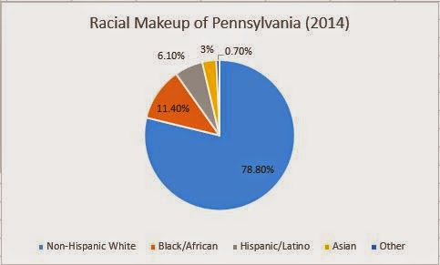
Most Pennsylvanians (as of 2014) are non-Hispanic White, at 78.8%.  Black and African Americans represent 11.4%, Hispanic/Latinos represent 6.1%, and Asians represent 3%.  The remaining .7% are others, including Native Americans and Pacific Islanders.  It is noteworthy to mention that in recent decades, the proportion of non-Hispanic White people has decreased to make room for an increasing number of minorities either through immigration or higher birth rates, including Africans, Asians, and Hispanic/Latinos. 

The Hispanic population is increasing the fastest, having grown 82.6% between 2000 and 2010.  While most Hispanic/Latino people are from Mexico, they tend to be Puerto Rican in Pennsylvania.  Their proportions are highest in Southeastern Pennsylvania at and near Philadelphia.  Similarly, Asian population growth numbered 60% from an influx of Chinese and Indians.

The six largest ancestries are German (28.5%), Irish (18.2%), Italian (12.8%), African (9.6%), English (8.5%), and Polish (7.2%).  In terms of religion, 80% of Pennsylvanians are Christian (51/29 Protestant/Catholic), 2% are Jewish, and 13% are non-religious.

Thursday, 5 March 2015

2.5 - Where in the World is Pennsylvania?!

In the previous blog post I said, "I will begin to churn out the atlas in these final weeks. Perhaps I will also write supplementary blog posts including these components of my atlas to prove I've been making progress." 

If you recall the outline of my atlas, below is the first introductory section.  I originally planned for it to be just one page, but it will probably take up more than one (each map will probably use one whole page, and then there's the text).

~~~~~~~~~~~~~~~~~~~~~~~~~~~~~~~~~~~~~~~~~~~~~~~~~~~~~~~~~~~~~~~~~~~~~~~

The world is a big place, and geography is our attempt to gain knowledge about it.  There is so much to learn about that it is impossible to know everything, and you will die before you do.  Most people shy away from geography because trying to learn it is always futile.  That's why I applaud you for opening this atlas.  Geography can be a mindlessly boring subject, but it can also be very fun and interesting.  As this is a "Buffoon's Guide", I will assume that you have little knowledge about the topic this book will address (Pennsylvania) and I will not bother you with endless facts and words.  Contained in this book is everything you'll need to know about Pennsylvania so you will no longer be a buffoon when it comes to the geography of this state.  And if you want to come across as a smart person to your friends, there's also other information contained for you to learn.  Although it is impossible to fully learn geography (or any subject for that matter), every bit you know will make you a better citizen of the world.

THIS IS THE WORLD
Above is a map of the world.  I apologise for it being a little sloppy, but it is recognisable as Earth.  If you didn't know that was a map of the world, slap yourself now.  Even those who do not actively seek to learn geography should know that, and if you didn't know that was the world, you must have been actively trying to avoid exposing yourself to geography.  But anyway, that is the world, and if you knew that already, good for you.

In order to make sense of the world, we break it into smaller pieces.  The largest piece used that's smaller than the world is generally a continent.  Different parts of the world say there are different numbers of continents, but for the sake of simplicity, we'll say there are seven.  Antarctica, the southernmost continent, is not shown in this map, but it exists.

North America is seen at the top left while South America is on the bottom left.  Both continents are sometimes simply called America.  Africa is in the central bottom and Europe is in the central top.  Australia, the smallest continent, is on the bottom right; Asia, the largest, is on the top right.  The division between Europe and Asia is unique in that it is not by water like the others, but by land.  The line between these two continents is not shown in this map, but it is the Ural Mountains in Russia (north of the Caspian Sea).  Many simply refer to both Europe and Asia and Eurasia.

Above we talked about the largest land divisions, the continents.  The largest sea divisions are the oceans.  Once again, the number of oceans the world has is debatable.  Notice that there are no solid divisions between the oceans, which is why many just say that Earth has one large ocean. 

Generally, there are five oceans used:
The ARCTIC Ocean spans the top of the map and is the northernmost ocean.
The ATLANTIC Ocean is between both Americas and Africa/Europe.
The SOUTHERN Ocean is the opposite of the Arctic Ocean and spans the bottom of the map (it is north of the unseen continent of Antarctica, which is the southernmost part).
The INDIAN ocean is south of Asia and is also bound by Eastern Africa and Western Australia.
The PACIFIC ocean is the largest of the oceans by far and is seen on the left and rightmost parts of the map, between Asia and the Americas.

This is all stuff you should probably know, but if you don't, I won't chastise you.  Knowing this will allow you the most basic level of understanding a world map.  Of course, this atlas talks about Pennsylvania, not the world.  Pennsylvania is not directly shown in this world map, but you might have noticed that something is shaded.

THE UNITED STATES OF AMERICA

On the world map, what is shaded is the country that Pennsylvania is part of, which is the United States of America.  The other map of the USA (again, apologies for it not being completely accurate) below shows a more detailed look at the country.  It also includes the states of the USA, with Pennsylvania being shaded.  On the corners of the map are the states of Alaska (you saw AK on the world map as disconnected).  Hawaii was not in the world map because it is a small island chain in the middle of the Pacific Ocean.  Puerto Rico is not a state, but at territory of the USA and is to the southeast of Florida, the USA's southeasternmost state. 

~~~~~~~~~~~~~~~~~~~~~~~~~~~~~~~~~~~~~~~~~~~~~~~~~~~~~~~~~~~~~~~~~~~~~~~

MORE FRUITS OF MY LABOUR

Taking advantage of the snow day today, I have also created two more maps that will be used in later sections of the atlas.  The first one is, of course, Pennsylvania.  The second one is Pennsylvania with counties.


Monday, 2 March 2015

2 - Preview of the Atlas

In the previous blog post, I was talking about a potpourri of various topics related to Pennsylvania.  Sadly, they probably won't make it to the atlas after a bit of extra thought (the previous blog post's purpose was to show that I was doing research and I wanted to present the fun parts of it).  I will still include several related topics other than just the physical and political geography of Pennsylvania.  And for once, I'll stop being vague and actually give you an outline of what this atlas will include:

COVER
WHERE IN THE WORLD?
OVERVIEW
- History
- Demographics
PHYSICAL
- Regions
- Rivers
- Elevation
POLITICAL
- Counties
- Cities
- Politics
APPENDIX: CLIMATE

In all honesty, I have been procrastinating quite a bit.  Yes, I have been reading up on all things Pennsylvania, but I haven't quite started the actual atlas.  In order to show you that I have, here is my rudimentary cover:


Of course, I haven't done anything else other than this cover (the atlas will be in black and white so my printer won't die), but I will begin to churn out the atlas in these final weeks.  Perhaps I will also write supplementary blog posts including these components of my atlas to prove I've been making progress, but we'll see about that later. 

The outline I supplied above is probably not sufficient (rats, I wanted to be vague), so I'd might as well specify these components even further.  At the end you shall see that making an atlas is no easy task.  The definition of an atlas is a "collection of maps", but this atlas is also a guide, so there will be a lot of accompanying text to make sense of the map (assuming you're a buffoon, you'll need it).

In the very beginning is the cover, which shall be one page only.  Please note the orientation of the cover, because the entire atlas will be landscape.

The next section is called "WHERE IN THE WORLD?".  This section should also be one page long and its ultimate purpose is to state where Pennsylvania is in the world using maps and text.  I will provide a hand-drawn* map of the world and highlight where Pennsylvania is, but I will also show it in relation to the United States. 

*All maps will actually be made with a computer because hand-drawing requires paper which is difficult to make digital and the quality will invariably suffer.  I will not draw from memory because the quality of the map will suffer, but I will also not trace mainly because I'm terrible at tracing.  The maps will be copied with my eye.  Accounting for time constraints, I will also not obsess over minute things such as if everything is lined up to latitude and longitude, because the maps aren't the centre of my atlas - they share that with the accompanying text.

After that section is an overview of Pennsylvania.  Here is where I had originally intended to put the interesting (or not) information in the previous blog post, but now it will just contain a brief history as well as the demographics of Pennsylvania.  In case you didn't know, demography is the study of human populations and is closely tied to geography (geography affects demographic distributions).  Each should be about a page long, but that may change. 


This map has no label, but if you have a decent understanding in geography, you'll know what theme this map addresses.  Do YOU know what the colours mean here?

After the overview comes the physical geography of the state, with one page each devoted to addressing the physical (not political) regions of Pennsylvania, the major rivers of this state, and major features in elevation (mountains, valleys, &c).  I had originally intended for this section to be of roughly equal length to the following political geography section, but there simply isn't as much to say about the natural features of the state compared to the artificial/human features.

Therefore, most of my atlas will address Pennsylvania's political geography.  One page will be devoted to electoral geography (how people vote in certain areas), but most of this section (and of the atlas as a whole) will address Pennsylvania's dozens of counties and major cities.  Each entry of a county and city may also include its local history and demographics (the overview section which includes these addresses them as it pertains to the entire state). 

This is a tall task because Pennsylvania has SIXTY-SEVEN (67) counties and I am determined to address them all.  If I can't, I will address them in bulk as in by region.  Indeed, this will not fit into one page, but I will die if I devote one page to each county.  I will probably be very brief about each county so I could fit at least five into each page.  Even so, that'd still be around a dozen pages of my atlas just of counties, but this is the boring part of the atlas and is meant as just a reference (even I don't read those parts of atlases... okay, I do).
As for the cities, I will not talk about every city and town in the state because that is impossible. I will probably just talk about the major/largest cities of Pennsylvania. Each city will include more information than those that will be found in an entry for a county, but because I'll do fewer cities, the sections for cities and counties should be around the same.

The atlas will end with an appendix that addresses the general climate of the state as a return to physical geography.  This will probably be one page.

Well, I hope that was an exhaustive layout of what you could expect from the atlas I'm making.  My fingers certainly are exhausted, and that seems so boring that your eyes may be exhausted as well.  Well, what's necessary to be put on must be included.  Phew.

Commented on the blogs of Frederik Sorg-Taylor, Eric Lang, and Paul Scott

Sunday, 22 February 2015

1 - An Introduction to Pennsylvania? Swell!

Warning:  All potentially offensive stereotypes are not to be taken seriously.  Videos may contain curse words and other inappropriate material.  Not recommended for unaccompanied children to watch.  Savvy?

Originally, I thought just doing this state would be too narrow which was why I wanted to do the world, but just Pennsylvania is already quite a bit.  I shouldn't have been so quick to draw conclusions.  I shall proceed onto the actual atlas next week, for my planning is complete.  As previously mentioned, the bulk of my atlas will contain physical then political geography.  As you shall see below, there is a lot of miscellaneous material that I probably will also add to the atlas at the very front and end so it's not just a book of maps.  For much of this cycle, I had been exploring Pennsylvania in general, not just specifically its geography, for though my atlas is primarily concerned with the gegraphy of the state, it is not just that.

Pennsylvania Guys, parody of Katy Perry's California Gurls.  If you like this video, I also recommend Pennsylvania Style (parody of Gangnam Style) by the same author. Same disclaimer applies. 
Several references were put into this video.  Here are some of the more well known ones:
1.  This is Phil from Punxsutawney:  We all know that 2 February is Groundhog (or woodchuck, or whistle pig) Day, when a groundhog determines how much more of winter there will be based on its shadow.  Although there are multiple predicting groundhogs, the most well known one is Punxsutawney Phil from Pennsylvania.
2.  Philly represent, cheesesteaks are cooking up:  The Philly (Philadelphia) cheesesteak is one of the renowned foods from Philadelphia and the state in general. 
3.  My Pops (works at) Dorney Park:  Dorney Park (and Wildwater Kingdom) is an amusement park in Allentown, the third largest city in Pennsylvania.  Interestingly, Dorney Park is much older than you might expect, with a history stretching back over 150 years to 1860.  In addition, the tallest rollercoaster in the park, Steel Force, is also the ninth longest one in the world!

If you found the Amish Airlines picture funny, here is a link to a "commerical" about it:  https://www.youtube.com/watch?v=bGDGrEYwbWw
Obviously, this makes fun of the old-fashioned lifestyle of the Amish.  Lancaster County is well known for its Amish presence.  However, the Amish are a very interesting group of people.  Their history dates back all the way to the Anabaptists of the 17th century before immigrating to Pennsylvania.  The term "Amish" is derived from the surname of the founder, Jakob Ammann.  As they are mostly of Swiss or German ancestry, the Amish also speak what is incorrectly known as Pennsylvania Dutch, which is actually a form of German (German in German, which is Deutsch, sounds like Dutch, and the misnomer has stuck around).  There even is a related amusement park called Dutch Wonderland.

Therefore, with that in mind, one part of my atlas may also talk about the linguistic diversity of Pennsylvania, said to contain the most distinct dialects of any state in the USA.  The two most well known dialects are, of course, named after and centred in the two largest cities of Pennsylvania, Philadelphia and Pittsburgh.

Commented on the blogs of:  Nathan Leung, Paul Scott, and Jason Shu

Monday, 16 February 2015

0 - Gee Whiz, It's Geography!

Last year when I was a freshman, I heard of several people talking about their genius hour projects, and I was extremely intrigued about this idea.  But when this project was introduced a few weeks ago, I had no idea what I wanted to do.  At first, I looked for things I spent lots of time on.  That included playing Civilisation II.  Well obviously they wouldn’t let me do that for my project, but I already had a plan of how to work my way around that.


You see, Civilisation II is an extremely complex game – never mind it’s from 1996 – with many real-life concepts to think of.  I think I liked this game so much because it was related to the passion I will soon talk type to you about.  Anyway, I thought I could devise a lesson using Civilisation II to teach social studies.  But then I realised that the Teddy Bear talk was limited to just five minutes, and I could easily talk for a whole hour about Civilisation II, especially if it’s relating the game to social studies. 

Rats, that was a really good idea, but it had to be tossed.  Then I moved on to another idea.  A few years ago I had started a novel, when I still had free time, but I never got around to finishing – or barely starting at all, for I was just at 2000 words.  Well, that seemed too cliché, so that idea was tossed.  I also had considered doing a stand-up routine for the presentation, but the presentation is not a performance, but rather just talks about what I did.  Yuck.  Well, besides, I have stage fright and I don’t feel like overcoming that fear.  But finally, after much deliberation, I found my true calling that was certainly related to my original idea:

GEOGRAPHY!  It sounds nerdy, especially because I can just stare at maps and find joy in them.  However, this is one of very few interests that has endured.  From our subscription to National Geographic, we have lots of maps in our house – got to love those posters!  We also have two atlases, one really old Chinese one that was printed before India had a billion people, and a Reader’s Digest Children’s Atlas of the World.  The former I looked at before I could read, and that was how I developed an interest in maps.  In elementary school, when I could read, Mother bought me the Children’s Atlas, and I credit that single book for developing my deep interest in geography.  By middle school, I had taken stabs at drawing my own maps and was a two time runner up in the entire school’s geography bee.  I still can’t forgive myself for answering those questions wrong. 
 

So for my project, I’m going into geography.  But specifically, I’m going to work on an atlas of my own, with my own hand-drawn maps, and original synthesised information about all parts of the world.  Supposedly it’s going to be concise, but it probably will go on for dozens of pages, which would make it definitely the longest thing I’ve ever written - I haven’t yet broken the 3000 word mark, but I should be able to with this.  And finally, this atlas should achieve my larger purpose.  While I certainly enjoy yelling at the television and going ecstatic when I answer a geography question in Jeopardy correctly, I can’t help but notice that geography is often undervalued as just trivia that makes someone seem smart.
 
Where is SICILY?

Geography is much more than trivia.  It’s a core social science that enables those who are literate in the subject to be intelligent world citizens.  You won’t believe how terrible people are at what I consider basic geography, and that is attributed to the fact that geography is a severely under-taught subject.  If schools like ours won’t teach geography for whatever reason (and any is unacceptable), then the next best thing is to make atlases so people can learn themselves.  And if they choose not to, it’s their own ruddy loss.
Edit:  Originally I had wanted to make an atlas of the entire world, but that is not feasible on account of time restraints.  Therefore, my atlas has been narrowed down to just Pennsylvania.  The atlas will be divided into two equally important parts:  One that deals with the physical geography (natural features such as rivers, mountains, &c.) of the state and the other dealing with the political/human (artificial features such as political borders and cities, &c.) features.  Fortunately, because making this atlas is the bulk of my project, it will clearly represent how much I've done in the project and how much more I need to do.  Therefore, by the middle of the project, I should have completed one part.  However, time at the beginning and at the end will be devoted to planning the atlas and preparing a presentation.

Commented on the blogs of:  Josh Chu, Trevor Bert, and Felicia Krauss